


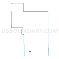
Wilton Voting District, Beltrami County, Minnesota
About
Outline

Summary
| Unique Area Identifier | 601155 |
| Name | Wilton Voting District |
| County | Beltrami County |
| State | Minnesota |
| Area (square miles) | 2.37 |
| Land Area (square miles) | 2.32 |
| Water Area (square miles) | 0.05 |
| % of Land Area | 98.01 |
| % of Water Area | 1.99 |
| Latitude of the Internal Point | 47.50595430 |
| Longtitude of the Internal Point | -94.99596480 |
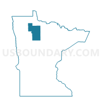
Maps

Graphs
Select a template below for downloading or customizing gragh for Wilton Voting District, Beltrami County, Minnesota


Neighbors
Neighoring Voting District (by Name) Neighboring Voting District on the Map
- Eckles Twp. Voting District, Beltrami County, MN
- Grant Valley Twp. Voting District, Beltrami County, MN
Top 10 Neighboring County Subdivision (by Population) Neighboring County Subdivision on the Map
- Grant Valley township, Beltrami County, MN (2,029)
- Eckles township, Beltrami County, MN (1,516)
- Wilton city, Beltrami County, MN (204)